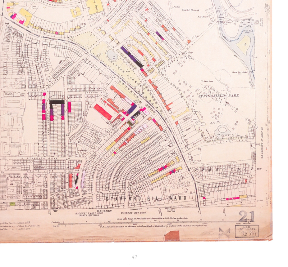
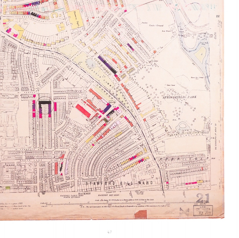
Several years ago, we featured some striking maps from a small exhibition at the London Metropolitan Archive. Each map was a detailed plan of a small part of London, the basemap being from 1916, with individual houses clearly shown. Many houses were just shown in white, but a number were coloured in various colours – showing which houses had been hit by bombs during the London Blitz in the Second World War, and the level of damage. Additionally, circles show the impact locations of V1 and V2 rockets. The maps were annotated with the damage/impact information by the London County Council, the city’s public authority at the time, shortly after the war finished, as a visual record of the extend and severity of the damage. The concept of colour coding individual houses based on an observed attribute is reminiscent of the famous Booth poverty maps, completed 70 years before, although of course recording a very different attribute. The yellow/orange/red/purple/black colour ramping used is clear and vivid.
Previously, you needed to visit the archive yourself and make an appointment to see the maps, but now, Laurence Ward, Principle Archivist of the London Metropolitan Archive, has taken these maps, professionally photo-reproduced them and included all 110 in this beautifully presented, large-format hardback book “The London County Council: Bomb Damage Maps 1939-1945“, which is published by Thames & Hudson this week, to mark the 75th anniversary of the first German air raids in London in September 1940.
The first thing that strikes you on opening the book is its size. It’s a weighty tome, containing the maps scanned at high resolution and reproduced in full colour, most across two pages and so presented approximately in A3 – large enough to see the individual house classifications clearly. It also has a large and detailed introduction including thirty pages of photographs, tables of statistics and background text – indeed the maps start not until Section 8. The book finishes with another 50 pages of well-reproduced black-and-white photographs of the bomb damage and recovery efforts. The author and publisher have taken time to make this a high quality piece, with an attractive font used both for the title and the accompanying text. The inside cover jacket includes a key to the damage colours used in the maps, detachable as a bookmark.
It is striking to see the level of damage that occurred in the City of London in particular – a huge swathe of land is coloured purple: “damaged beyond repair”. The map, and photographs, of what is now the Barbican area, show the near complete destruction which resulted in this whole district being redesigned – not even the old road network survived. The image here at the top is an extract of one of the pages of the book, showing the map for the Stamford Hill/Clapton area. The circle shows a direct V1 flying bomb strike, and the damage to the surrounding houses is indicated in the colours in/near the circle. The area’s street network is similar today.
The book is immaculately presented and is an essential part of any London-phile’s coffee-table book collection. It available to order from all good booksellers, including from Amazon UK.
Thanks to Thames & Hudson for the review copy.
Hi, please can you tell me if these maps cover Dulwich?
Thank you
Ron Bush
Hi Ron, yes they do, Dulwich is Plate 127, on pp 200-1.
could you please tell me if these maps cover Shoreditch in any detail. I am currently researching the buildings in this area/
Do the maps cover Shoreditch in any sort of detail. I am currently researching the social and transport history of this area.
Hi Peter, yes, they do cover the Shoreditch area, at a good level of detail.
I am very interested in tracing an incident from 1944-45. Below is the request I have sent to other agencies. Is there a map I can use or purchase showing accurate data for V2 impacts?
I am trying to verify a close call with a V2 that my father-in-law had at the back end of 1944 or the beginning of 1945. He was building shuttering moulds for the Mulberry Harbours. He was either at Tilbury or one of the two London Docks used for this purpose. They were East India or South Dock close to the river Thames.
He said he saw a vapour trail in the sky; and the weather was clear and sunny. Someone shouted, “Get down”! So he hit the dirt quickly and escaped unhurt. He said there were casualties but I am unsure of this fact. Sadly he is dead now, so I can’t trace the facts any other way but by this method.
The closet information I have is this below??
December 4, 1944. Weather conditions? December – Cold and dry with near normal sunshine.
Mean Temperature 3.6°C
Monthly Highest 12.5°C Total Rain 30 mm
Monthly Lowest -4.9°C Total Sun 41 hrs
The month began with mild, changeable weather, and on the 3rd the maximum temperature rose above 12°C. At the end of the second week, a quieter spell of weather developed with some dense fogs occurring. However, a short unsettled interlude on the 17th produced nearly 12mm of rain. On the 20th, the fog was very dense, and over the Christmas period there was freezing fog. On both the 26th and 29th the maximum temperatures were only minus 0.8°C. Tilbury
I’m from Australia but my paternal grandfather was born at Bethnal Green then the family moved to Walthamstow. He had many siblings but one of his sisters died along with her husband from a V2 bomb which dropped about 4am on the morning of 14th September 1944. They were living at 14 Farnan Avenue Walthamstow. A number of other people were also killed nearby in Farnan Ave. I’m trying to find out where this V2 landed but cannot find the location or where a memorial plaque would be. I’ve taken myself for a walk to the address with the help of Google Earth and found the location but guess their building was fully demolished on that fateful day. I have searched numerous sites on V2 bombs which landed in Walthamstow but it’s left me more confused than ever. Hope you can advise me of sites I may have missed.
can you tell me when 18 mulgrave road was bombed in fulham ,
I,m interested in seeing a map of bomb locations in St; Marylebone, 1940, but don,t know how to search for it. Any advice would be of great help.
My mother lived with her mother at 7 Sophia Road in Leyton before the war. Mum got evacuated and my grandmother moved out of the property. After the war they went back and no 7 was apparently the only property still standing, as the others had been bombed.
I am interested to find out what sort of bomb destroyed a row of houses in Parkside Way, Harrow. There is a multiple grave in Harrow Cemetery where all those killed are buried.
I remember the destroyed area but of course was in my push chair at that time.