
Mapping London has always been most interested in modern maps of London, however we are happy to make the occasional exception, and so when this reproduction of a map that was over 250 years old crossed the desk at Mapping London Towers, we were keen to take a look.
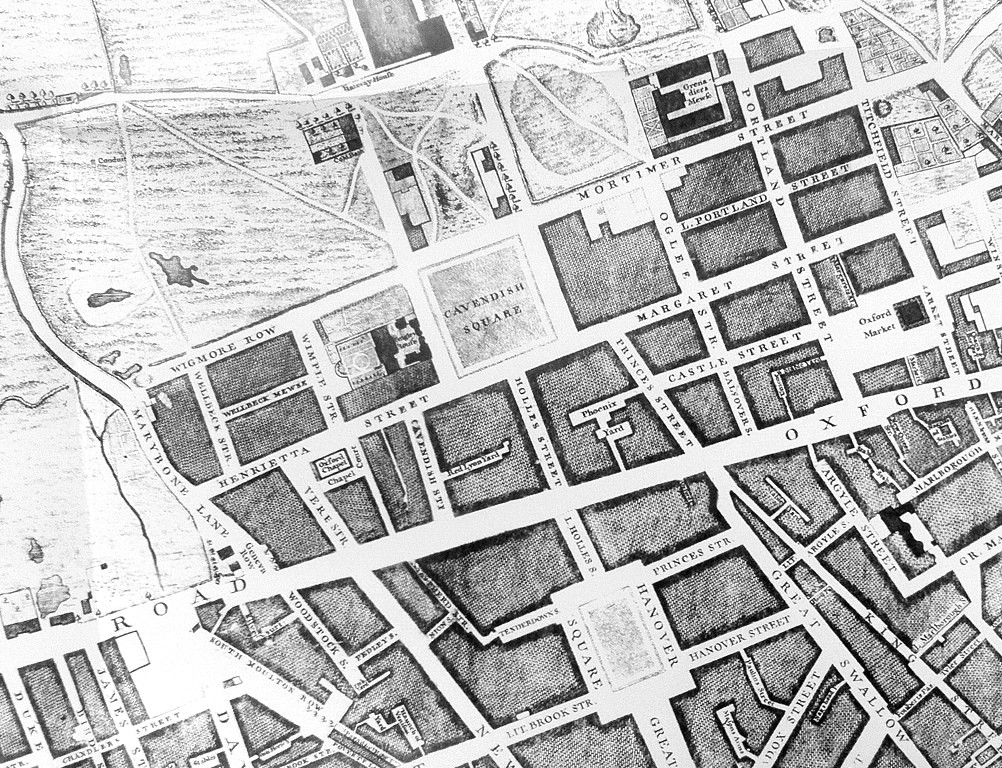
The original map was surveyed by John Rocque, engraved by John Pine and first published in 1746. It was the most detailed map of London in its time, with over 5000 street and place names. Modern publisher Old House has been to the National Archives to retrieve the twenty four sheets, take high quality imagery of them, and produce a modern reproduction on four large sheets.
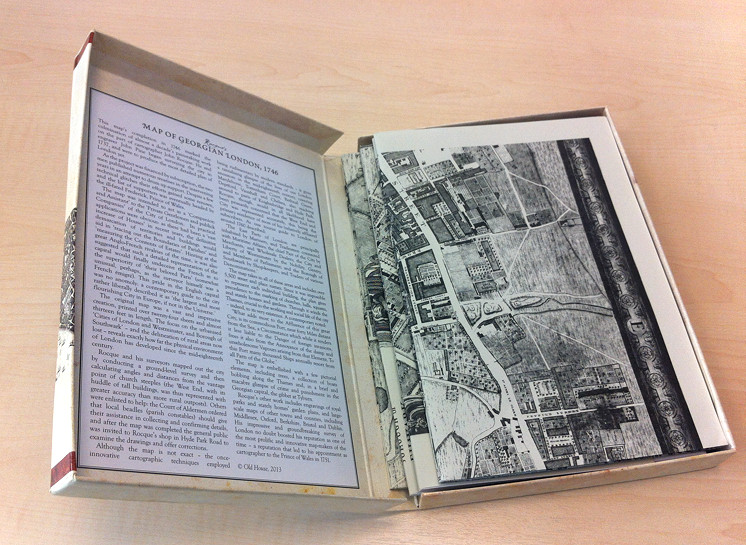
The presentation of the reproduced maps is excellent. They come in an attractive card box, which folds out like a book (see photo below) with a short history of the map on the inside cover. The history notes some details of the map’s cartography, such as the inclusion of the infamous gallows at Tyburn. Because the map is back and white, symbols are often used rather than colours, to denote features. For example, orchards and small woods are shown as groups of individual trees, each shown with a shadow. There are many tiny alleyways, most with a name, although the smallest ones’ names are not always readable on the reproduction, which is slightly blurry in a few places.
Each of the four sheets forming the map are folded to A5. Each sheet is over a metre wide once folded out. Although the map obviously looks suitably old, it is, slightly surprisingly, printed on glossy paper, which gives it a slightly less antiquated look and feel. You’ll need to trim the edges if joining the four sheets together to make a huge map – and you’ll need a 200cm x 120cm space on your wall!
The map, and particularly its presentation in the box, makes for an attractive present for a map-loving Londoner, particular one who lives in Zone 1-2 and so can find their modern location on an old map – London of course having been much smaller 260+ years ago.
See Old House books for full details, and here is a direct link to the map on Amazon. Note that, at the time of writing, the alternative sellers on Amazon are selling the map for £10 cheaper than Amazon is itself. Old House have produced other reproduction maps of London too, such as Elizabethan London in 1572 and Victorian London from 1863.
Thank you to publisher Old House for the review copy.
It’s a great Map, but as it is long out of copyright it should be in the public domain and as such it is a little galling to seesomeone profiting from someone else’s work several centuries ago.
I totally agree – if you can find an original set of the maps then there is nothing to stop you from scanning them in at high resolution and posting them online with an open licence, so that all can indeed enjoy. AFAIK The National Archives do have restrictions on photographic reproduction of their maps, so that particular set may not be the one you could use.
ps. Here is a direct link to one of the sheets at the National Archives: https://images.nationalarchives.gov.uk/assetbank-nationalarchives/action/viewAsset?id=29154&index=5&total=12&view=viewSearchItem
No doubt the publishers will be paying a hefty licencing fee to the National Archives.
Hardly. Or are you saying that every publisher that publishes an out of copyright book (Dickens etc.) is doing something “wrong”?
All this stuff IS in the public domain, and you can find it if you go and look for it. But what Old House have done is take this historic map, gone to the trouble of reproducing it (and on good quality paper if their 1863 map is anything to go by), put it in a nice box and making available for people to buy and keep. I can’t see how there’s anything wrong in that.
I’m not sure if you realise it, but the publishers, Old House, are specialists in publishing facsimiles of historic publications. They have quite a few out, including other maps, the Bradshaw Guide made famous by Michael Portillo (that one is a big seller btw), and reproductions of various Baedeker guide books. Personally, I think what they’re doing is marvellous.
Publishers trying to earn a crust by publishing or digitizing long out-of-copyright books or maps aren’t doing anything wrong.
However public bodies who own physical copies of rare maps or books and allow commercial companies to digitize them, and assert copyright over the images, are doing something very wrong indeed.
I have no objection to a museum or library paying for the service of having a map digitized but they should retain copyright of the images and, in my opinion, release them into the public domain. Of course I have no objection to them charging (modestly) for a download, or selling a CD of images, but they should not be re-introducing copyright on images of something so old.
And Rocque’s maps do cover London much further out than the bounds of Zone 1.
I live in Hounslow and find his map around Osterley Park useful for showing the history of some of the landscape features. The Museum of London team using geophysical techniques in Gunnersbury Park on the borders of Hounslow and Ealing were referring to the Roque maps in their study.
Can I suggest you take a look at the Locating London’s Past website which provides a geo-rectified version of Rocque’s 1746 London, Westminster and Southwark map
http://www.locatinglondon.org/
Sarah, thanks for the link to an incredibly useful web resource.
Yes, thank you thank you thank you! This website was a phenomenal help!
Thank you for providing a genuine link to the map. I totally disagree that people in the 21st century are profiteering from such antiquities. Not all of us have the funds to purchase books of such huge mark ups!!!
Hi I’m trying to find out what was on the site of glengarry Road SE22 London for my house was built on some sort of burial ground. The road is opposite East Dulwich hospital
Can you help me?
Tashan Essien
Tashan Essien you may find this site helopful://www.dulwichsociety.com/dulwich-estate-maps
@CFJC75 or here!
https://t.co/olRDMrcv3h
I know this is a very old post, but I felt this info may prove interesting regarding the reproduction and reissue costs. Whilst the original map sheets remain in the public domain, it is down to the owners of the originals whether copies can be made and what licencing restrictions they wish to apply. Digital copies of the original maps can now be download from several sites, including the British, French National, Yale University and Stanford University Libraries, plus the Library of Congress.
However, if you want an original map, printed from the 1746 etching, as sold in one of the original offerings, you should have a look at how much a large (12′ 7″ × 6′ 7″) “Zone 1/2” map (practically the same area covered in the Locating London link given by Sarah Jones of MOLA in her post above), and made from 24 original sheets, can sell for at
https://www.christies.com/lot/lot-a-large-map-of-london-john-rocque-5818384 .
I thought the guide price was optimistic at £30‐40000, but at more than double that, and over £1000/sqft, it’s a very expensive wall covering.
(The same map can be downloaded from Wikipedia (Library of Congress copy) and printed at ~320px/in should you wish to achieve the same scale and size.)