
Mapping London is currently abroad on holiday. So here’s a post on location – not of a map of London, but of New York City. More specifically, a map of Green-Wood Cemetery in Brooklyn, one of the five boroughs of the city.
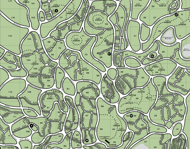
Green-Wood covers a considerable part of Brooklyn, it is nearly as large as the famous Central Park, across the river in Manhattan. It is 176 years old and designated as a National Historic Landmark, and although it doesn’t have “world famous” people buried in it, such as Karl Marx in Highgate Cemetery in London, it does have, amongst its 560000+ buried, a number of people of significant note, who are detailed on the free cemetery map that you are handed at the main entrance. One of these people is Samuel Morse, inventor of the telegraph and the eponymous code. It is by far the the largest cemetery your author has ever visited, much larger than any of the “Magnificant Seven” Victorian cemeteries in London, and its road and path layout is fantastically detailed, as can be seen on the extract of the official map here (PDF here). It should be noted that the map is orientated so that south-east is up.
There are some fine views over to downtown Manhattan, from some of the hilltops in the north-west part of the area – the climb up Battle Hill (named after a battle in Brooklyn, part of the American War of Independence) is close to the entrance and a good start to a visit here. It is a working cemetery, with new burials happening, and various unfilled plots in some sections. The cemetery includes a chapel that is closely modelled on the Tom Tower in Oxford, and is a short distance from the the Gothic-style entrance arch of the main gate.
The cemetery is in the care of the Green-Wood Historic Fund, who supply the map. The paper copy is attractively folded into a booklet. The green, black and white colour scheme is simple but clear, creating an attractive map which conveys the complexity of the path network, the path names (which are well signposted) and the location of the key sites. The curving nature of the roads and paths means that careful consultation both of the signposts and the map, throughout a visit, is essential, if you are to locate an exit in a timely fashion!
[Update: A few days after my visit, a historic map used at the 1776 Battle of Brooklyn, and newly acquired by the Brooklyn Historical Society and the Green-Wood Historic Fund, was unveiled. It is on display at the Brooklyn Historical Society until February 2015.]
Thank you to the Green-Wood Historic Fund volunteer who gave me the map and also detailed the best route to take for my visit.