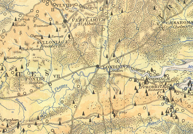

Here is part of a map, The Map of Roman Britain, Second Edition, published by the Ordnance Survey in 1931 and scanned by Bibliographics. The extract above shows the area taken roughly up by the modern Greater London conurbation, along with the surrounding area. The black triangles and circles show known Roman villas and other settlements, while the lines show the main Roman roads at the presumed height of the Roman occupation of Britain – dotted lines show where the road route is not known exactly at the time of the map’s production. The patterns of dots/circles show wooded areas.
The eight roads shown, clockwise from the north, are:
- Ermine Street (sometimes Erming Street), heading north to Lindum (Lincoln). Now the A10/Kingsland Road.
- A track heading north-east from the Lea (at Stratford) through Epping Forest.
- A road heading east to Caesaromagus (Chelmsford) and Camulodumum (Colchester). Starts at what is now Old Street, then Hackney Road and Old Ford and maybe Roman Road, then the A118. Crosses Ermine Street at Shoreditch.
- Watling Street, heading south-east to Rochester, Durovernum (Canterbury) and Dover. Now the A2.
- A road heading south to Burgess Hill – little trace exists.
- Stane Street (sometimes Stone Street), heading south-west to Chichester, via Alfoldean (quite near Horsham).
- Portway, heading west starting along Farringdon Road and Oxford Street, then through Pontes (Staines) towards Calleva Atrebatum (Silchester).
- Watling Street, heading north-west to Verulamium (St Albans). Starts on Park Lane/Marble Arch, at the junction with Portway, and runs along the A5/Edgware Road and A5183.
London Bridge is also visible, the only bridged crossing of the River Thames near London at the time. The next bridge upstream is at Pontes/Staines.
The Ordnance Survey has produced several further editions since, with very different styles, but there is something very attractive about this particular one. The sixth (2011) edition – Roman Britain (Historical Map and Guide) – is available from Amazon.
Extract from the scan by Bibliographics.
London’s Roman Roads and where to find them. https://t.co/6IgXlI5Hkb
Do you recognise London here? This is #London of #roman times #llovelondon https://t.co/lfqojAvtoc https://t.co/z6KqiHb8tB
Do you recognise ~London here? This a long lost city from #roman times #lovelondon https://t.co/7gyFIHJ5OH https://t.co/735TTaafaR
RT @cityreadlondon: Do you recognise ~London here? This a long lost city from #roman times #lovelondon https://t.co/7gyFIHJ5OH https://t.co…
Epping Forest and Wanstead walks over the weekends show the history of Londinium. London’s Roman Roads via… https://t.co/2Xr4ThmT0Q
@Hackneycyclist Hackney Road is apparently an ancient Roman road
https://t.co/brOoU01hy3