
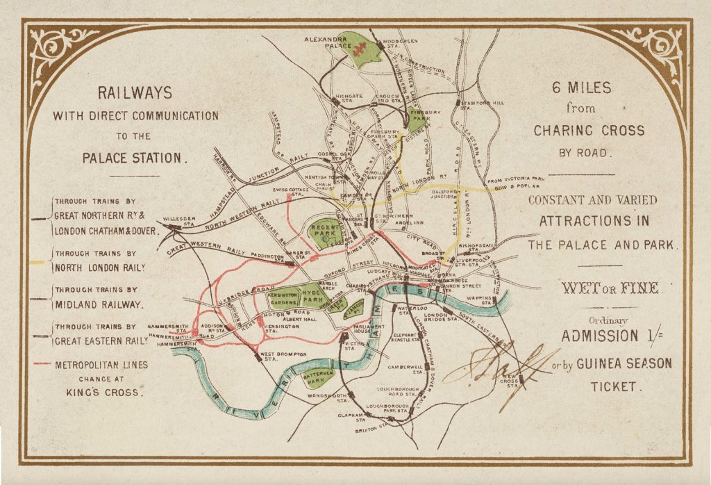
This map, dating from 1875, appears on the back of a “Guinea season ticket” for entry to Alexandra Palace, in north London. The palace was recently restored and public entrance is now available to some areas for free.
It’s a nice, vintage map, and the use of colour is interesting and attractive, with key parks coloured in and named, and the River Thames drawn with blue lines along the direction of flow. The map is finished with a gold decorative border. It does suffer a little from overlapping of names and lines in places (e.g. around Bank). It shows not only line names (and colours) but also major road names. Angel is referred to by the “Angel Inn” (the tube station hadn’t yet been built – this is pre deep-tube) and interestingly the main line King’s Cross station was called Great Northern station – but the tube station nearby is called King’s Cross.
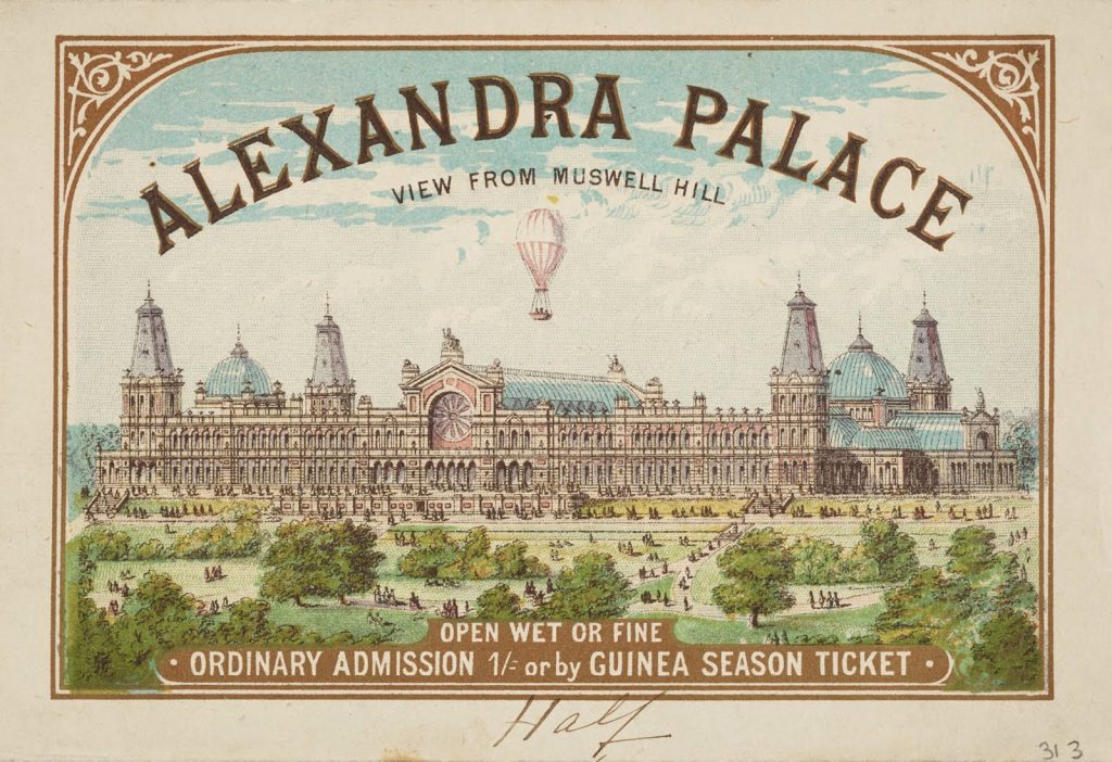
At the front is a grand drawing of Alexandra Palace itself, mc=uch as it looks today, but with the addition of a hot air balloonist above. It states the view is from “Muswell Hill” which is curious. At first glance, looking at Alexandra Palace from the opposite direction appears to line up, while the “back” of the current palace, which faces Muswell Hill, is without the promenade or much of the park, and spoilt by a car park. However, perhaps 140+ years ago it was indeed more symmetrical.
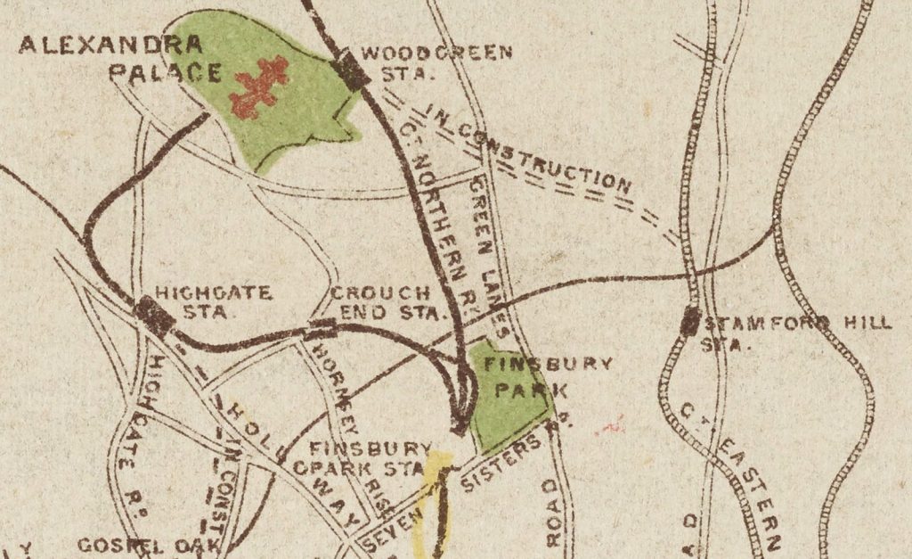
However, the current range of rail options to the palace are much reduced – the Finsbury Park – Highgate – Alexandra Palace Station line is closed (and is now the Parkland Walk) while the Stamford Hill to Wood Green link never got built (although it might appear as part of Crossrail 2 in another twenty or so years). The Yellow line is the North London Line but this offers no direct trains to Finsbury Park any more.
From the Alexandra Palace collection on the Google Arts & Culture project.
Alexandra Palace Guinea Season Ticket — https://t.co/APajGonhHu
The “Stamford Hill to Wood Green” line did get built as the Palace Gates branch, which was closed in the early 60s.
The image and map pre-date the development of Muswell Hill. Muswell Hill Broadway was only developed in the 1890s, and Collins and Edmundson (the principal developers of the suburb) only really go going in the early 20th century. So it isn’t surprising that the view of Ally Pally is unsullied by any terraced housing – in 1875 the Palace and Park would have been surrounded by fields.
The view is of the second Palace – looking “up” Muswell Hill from Hornsey. You can see this from the terrace and location of the steps. The other side would have steps leading down from the Great Hall to the former Ally Pally railway station.
1875 is significant, as this is the year the second Palace opened – the first having burnt down within days of its opening in 1873.
PS. The Stamford Hill to Wood Green line opened in 1878 (a couple of years after the date of this ticket) and closed in the 1960s. It had a separate station from the current Ally Pally station (seen by its old name of “Wood Green” on the map) – namely Palace Gates Station. Wood Green Shopping City was built over much of the Palace Gates’ line infrastructure.
The document is a publicity flyer/location map. It isn’t a ticket, it just quotes the prices.
A shilling (5p) was a lot of money in 1875. This was certainly not an attraction for the working classes. A season ticket was a guinea, 21 shillings (£1.05). This was way beyond a woring man’s means at the time.
The map erroneously shows the Great Eastern Palace Gates branch as running from Stamford Hill instead of Seven Sisters. It operated from 1878 to 1963.
Ollie needs to be a bit more careful with his research, or just talk to a railway enthusiast.
The Stamford Hill to Wood Green link that ‘never got built’ might be the palace gates line? https://en.wikipedia.org/wiki/Palace_Gates_Line
It was NOT from STamfords Hill, it was from Seven Sisters, opened in approx 1878 & closed in 1962-3.
A tiny bit remains at the North end, used as carriage sidings for Bounds Green Depot
So what is the “In Construction” line shown from north of Kings Cross to Highgate?