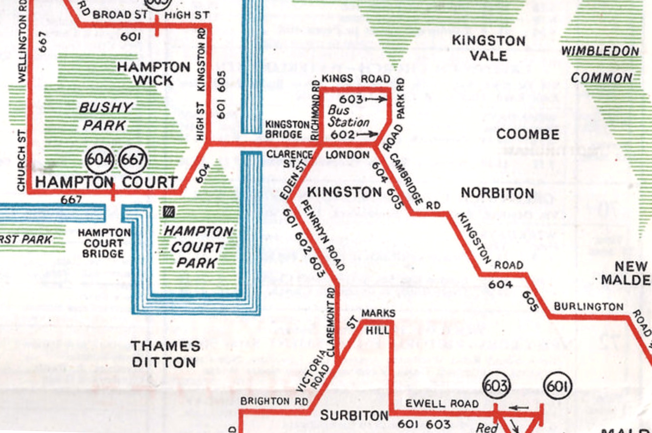
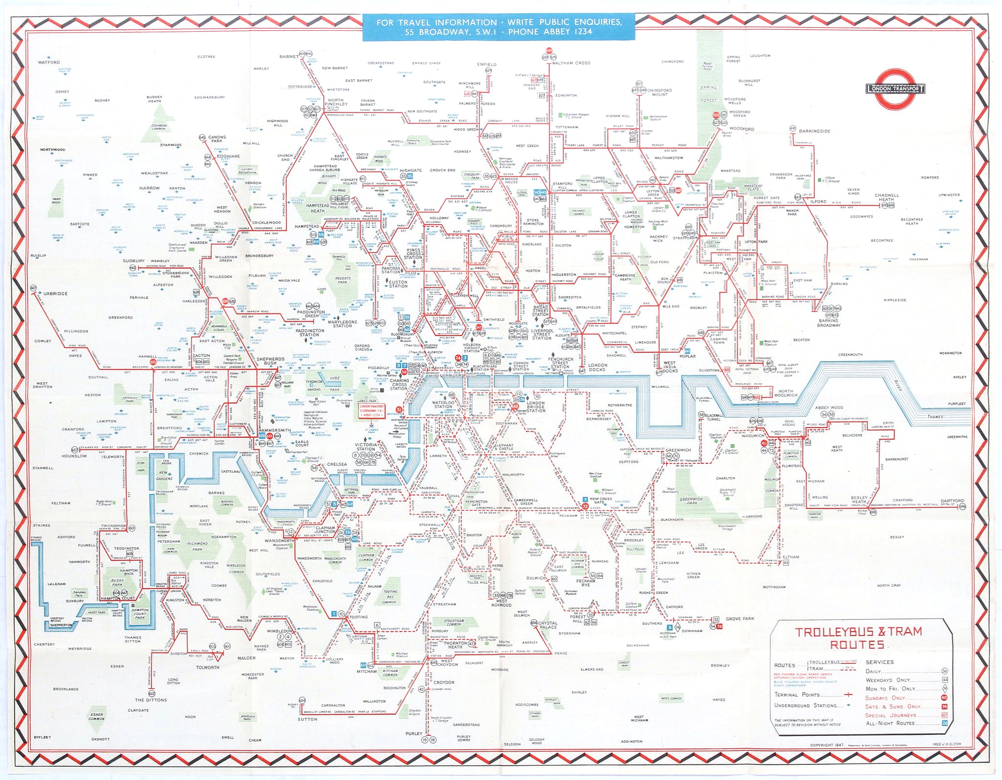
Readers of Mapping London, and Londoners in general, will be very familiar with the striking straight lines of the Tube Map. But you probably won’t have seen this map before, which employs the same kind of schematisation to show London’s now completely vanished tram and trolleybus network (there is a tram in south London now, but it wasn’t around when this map was created). The map, while simplifying the corresponding road network to 45-degree angles – just like the tube map – includes many other details, such as tube stations, parks (with names), towns and suburbs. The River Thames is there of course, and is also subjected to the 45-degree rule. Road bridges across the river are shown and named, regardless of whether a tram or trolleybus crossed them.
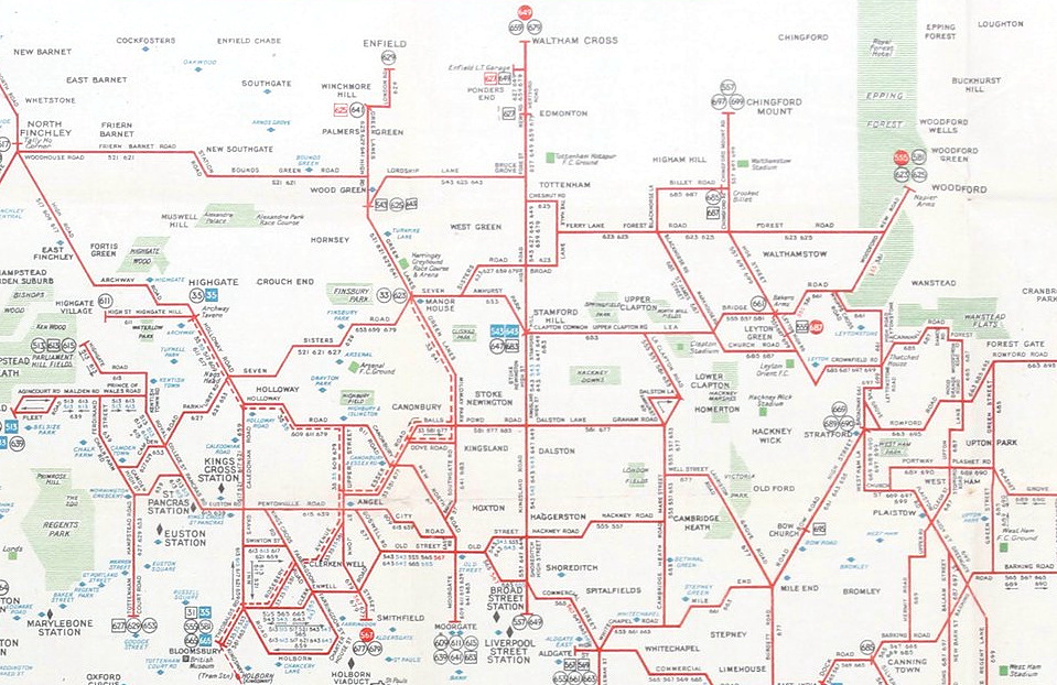
Some angles don’t work too well – Seven Sisters road for example, is shown as an extremely wiggly road here, whereas in actual life it’s very nearly a straight line – just one that travels at around 60 degrees from north, rather than multiples of 45. Because it inevitably connects with further trolleybus and tram routes along its length, the map has to stay fairly true to real-life. Hence the dizzying wiggles:
As this map shows, lovely as it is, the simplicity of the tube map doesn’t translate very well to London’s complex road network. So perhaps this is why the idea almost didn’t survive for above-ground networks, and London’s more modern bus maps (now discontinued) have always used the actual geographical network. However, there is one modern successor map – the central London bus map for tourists (see the third example on this post).
Another oddity is that the map is quite “purist” in terms of colour. It doesn’t colour-code the lines – they are all shown as red, even where multiple ones run together. Instead, it relies on service numbers running along most of the line segments. Curiously, it dashes the trams, rather than showing them a different colour. Only the Thames, nightbus end points and Underground stations are shown as blue, while green is reserved exclusively for parks. As trolleybuses and trams are almost always above ground, maybe the parks (and stations) were considered to be key navigational aids of people needing to know when to alight.

So, we think this is a striking but flawed example of a schematic London network map: it tries to simplify the geography of London, and in many cases it works well – but sometimes, the road network just doesn’t work out. A hybrid approach, such as this bicycle route map, is perhaps a more successful attempt at a “tube map” for the above ground realm – only drawing straight lines further out from the centre, where the network connects less repeatedly.
Thanks to Christopher Wyatt for highlighting this map on Twitter. Bottom map is an excerpt of an image © mildmaypark on Flickr.
Trolleybus & Tram Routes (1947) — https://t.co/11r6Qw74sN
Could we have a loadable ( *.pdf ?? ) version, please, pretty-please?
Oh wow!
I just love this map. I had no idea it existed Is it possible to buy a copy?
I feel a ‘connection’ as my father was a trolleybus driver. He worked at Finchley, Wood Green and Palmers Green garages. We lived at Bounds Green so had the best of worlds – trolleybuses, underground trains and mainline trains.
I’ve just been busy online, ordering original bus tickets!! I’ll give those to my eldest son who also shares the same interests.
Ebay is probably the best way to find this map, unless it is available at the London Transport Museum shop.
I cannot see from the first map above whether a trolleybus route ran along Piccadilly. I have a memory of one turning left onto Piccadilly out of Lower Regent Street – but my wife says there never was one that ran along Piccadilly! The map is tantalising…..I cannot get it to zoom enough to see the detail. If my memory is correct, can you tell me the number of the trolleybus in question, please? Or am I remembering a tram, instead?
Sorry, but your wife is right. Trams (and then the trolleybuses that replaced the north London part of the network) never got in to much of the west end – Victoria (Vauxhall Bridge Road) and Tottenham Court Road / Warren Street were the closest they got.
Basically, the wealthier areas of London did not want trams on their patch.
Take a look on here for some interesting info! https://en.wikipedia.org/wiki/Trolleybuses_in_London
Check this out: https://t.co/vl7uVgaXZQ @nevhomer
Ooh what a smashing old map 🤓 https://t.co/ueFfIqPy5K
Great piece by @MapLondon of London’s 1947 tram and trolleybus network
https://t.co/yZq9rIu0GO
with big map… https://t.co/wiL37PPtI4
God, how I wish both trams and trolleybuses had been kept in London. Imagine how much cleaner the air would be with them instead of hundreds of diesel buses, and probably a load less cars as well, if the service was way more attractive than the current service using the aforementioned diesel buses.
@hera_putspace London’s trolleybus and tram routes, 1947. Night tube? You could go from Piccadilly to Beckenham all… https://t.co/60jbblLwzI
RT @lastnotlost: Great piece by @MapLondon of London’s 1947 tram and trolleybus network
https://t.co/yZq9rIu0GO
with big map
https://t.co/f…
@citycyclists @psimonk @ToryCycling Tram map 1947 via https://t.co/yZq9rIu0GO https://t.co/gnXbgrGZbv
Seems strange-the trams were removed because they were obstructing london’s motor traffic. Today, there is a segregated ‘cycle super highway’ along the thames embankment – exactly where the trams ran -and it’s causing a hundred times the obstruction that the trams caused.
Progress, Mr.Khan?