The same day that James received a historic picture map of London that we eventually dated to around 1908, mainly based on the appearance of the 1908 Olympic Stadium in what is now White City, we noticed a Tweet from Collins about a new book that they had produced in conjunction with Mapseeker Archive Publishing. The book is “A Guide to London 1908” and has just been published. 1908, of course, being the first time the Olympics came to London, and we are less than two months from the third time, so a timely publishing.
The book, the result of an impressively detailed trawl of historial archives, mainly focuses on the Games and includes various prints of Olympic tickets, route maps and rules for competitors and events. It also has some more general London memorabilia from the year, including a list of hotels, bus routes and cab fares, and a gazetteer of interesting places to visit for the 1908 tourist.
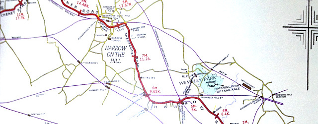
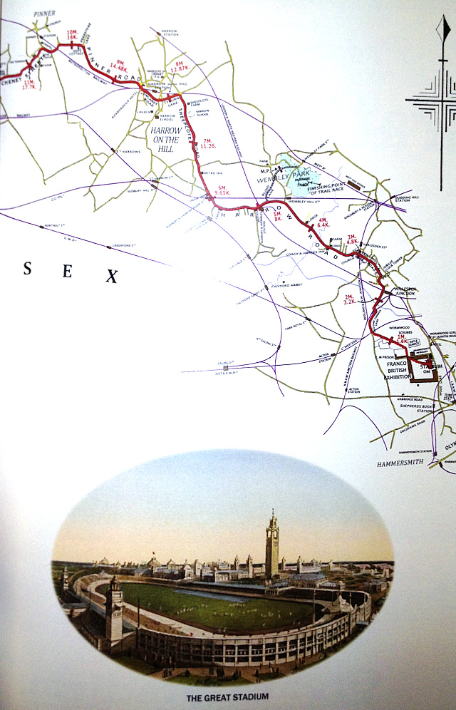
The highlight for is a map of the 1908 Olympic Marathon route, from Windsor Castle to the stadium, the first time I’ve seen such a map. The map has been painstakingly reconstructed from scratch, based on the old and very much degraded original mapping. An accompaning historic document mentions that a “gun or rocket” would be fired at the 24th, 25th and 26th mile marker.
This was the first marathon to be 26 miles and 385 yards, and very much set the standard. Now I’ve heard both from people saying that the marathon was specially extended by 385 yards to finish in front of the Royal Box, and from others that say this is apocryphal. The book has a good go at putting the stories to rest once and for all – it has done the in depth research and has devoted several pages to the minutiae and miscellany of the historic marathon route.
There’s also some more general historic Bartholomew (now part of Collins of course) mapping of London, taking up numerous plates at the back of the book and showing the tramway and bus routes of the time. One plate is of the borough boundaries of the time – many of which were subsumed, and London itself significantly expanded, sixty years later.
Thank you to Mapseeker Archive Publishing for sending us a review copy of the book, from which I’ve photographed part of the marathon map, above. You can find the book here on the publisher’s website and also a commemorative print of the 1908 Marathon route.