Mapping London
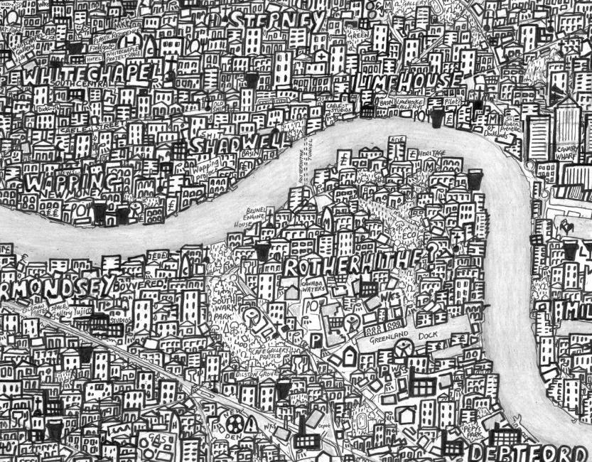
Highlighting the best London maps
  • Bookshop
  • Apparel
  • Art
  • Data
  • Events
  • Historic
  • People
  • Tourist
  • Tube
Home » Search results for Stephen Walter
Stephen Walter’s Hub Map of London
  • Art
Jun03

Stephen Walter’s Hub Map of London...

posted by Ollie

The above is just a small extract from Stephen Walter’s “Hub” Map of London, a hand-drawn map of painstaking detail, drawn during 2007-8. You can see the full version of Stephen’s map on his website, along with his most famous work “The Island”, which is in a similar but more autobiographical style, and featured in a British Library exhibition London, and London Subterranea, which was commissioned by the London Transport Museum. Stephen is exhibiting his cartographic work, including new material and an interactive exhibit, at an exhibition, From the Anthropocene, at the Londonewcastle project space on Redchurch Street in Shoreditch, from 3 to 26 July. The exhibition is presented by TAG Fine Arts. Map copyright Stephen...

»»
London Mapped Jigsaw Puzzle
  • Art
Mar28

London Mapped Jigsaw Puzzle...

posted by Ollie

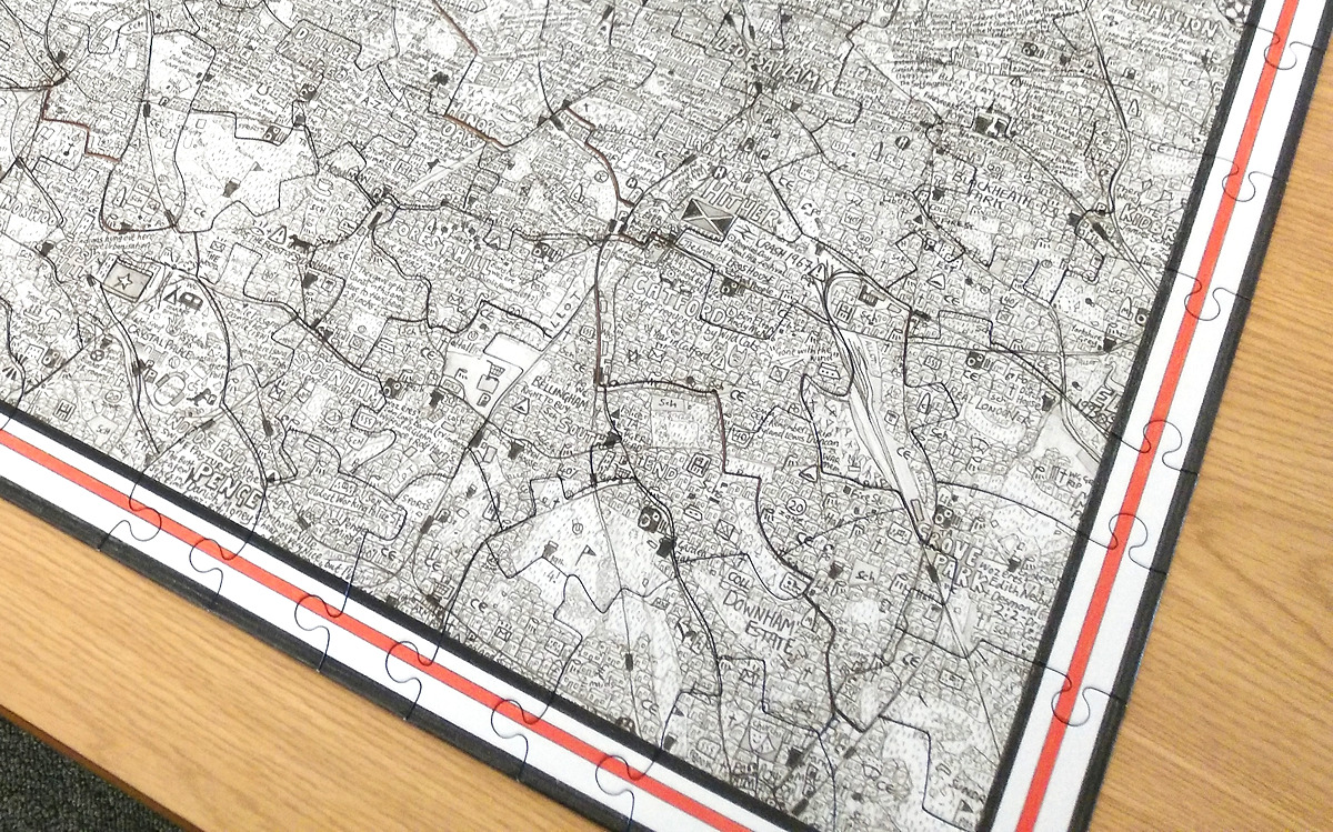
Mapping London has long enjoyed Stephen Walter’s fabulously detailed, painstakingly created pencil-sketch maps of London, and now one of his most famous works, The Island, has been made into a jigsaw puzzle. It was launched late last year by publishers Prestel UK and comes as a 400-piece work. The team at Mapping London Towers likes to think that it knows London’s geography pretty well – after all, we’ve reviewed over 300 other maps here so far. So we assumed that completing this puzzle was going to be straightforward, something to piece together in a short break. How wrong we were – it took three of us nearly six hours each (over three long lunches) to complete the puzzle. There are various challenges making it harder – the map is black and white, which means there are no colour clues, apart from the red banded pieces forming the edge of the puzzle. In addition, as a semi-autobiographical work of the creator, some of the place names are spelt in local vernacular or slang. So going by simple place names is harder than you might expect. Conversely, if you have a good knowledge of historical spots in London, some demographic statistics (such as the area with lowest life expectancy) or can recognise flags and know which London neighbourhoods the corresponding nationality has an established community in, then this can be invaluable. Subtle changes in the density of the penciled buildings can also help. Stephen was never afraid to voice his opinion on many areas, and even be downright derogatory about some of them – perhaps sometimes deserved. But you really need to know London’s rough as well as its smooth, for these to help with the task of solving. The jigsaw puzzle pieces themselves are also...

»»
Mayfair & St James’s
  • Art
May15

Mayfair & St James’s...

posted by Ollie

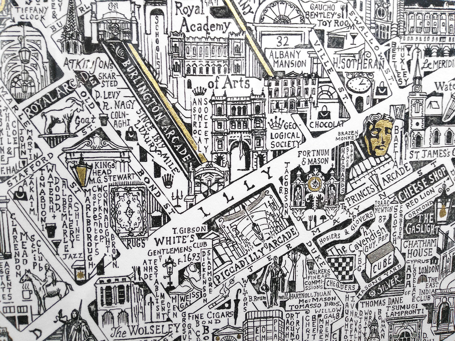
We’ve long been fans of artist Stephen Walter’s monochromatic cartographical style and have featured numerous map-based artworks by him over the years. It’s been interesting seeing his style subtly evolve, from intense and slightly angry detections of “seas” of houses and caustic comments, to the slightly more restrained, but still very distinctive, style of his more recent works, including this piece, “Mayfair & St James”. The work covers the opulent Mayfair and St James’s districts of London, in Stephen’s forensically detailed “sketching” style but with the addition of gold leaf to highlight certain roads and park areas. The glint of the gold leaf adds an appropriate sparkle to the map of the area. Stephen has also extensively written labels vertically, with lines of letters falling down. This helps with the annotation of the area and is a rather pleasing style that makes it feel less like just being an intensively detailed map. The vertical writing, and level of detail, ensures this is a work that people will spend quite a bit of time looking at. The work is co-published by by TAG Fine Arts and Shapero Modern and the work is available in an signed and numbered edition of 75 from the two galleries. Thanks to TAG Fine Arts for inviting Mapping London to the London Original Print Fair, where this work was...

»»
The Rivers of London
  • Art
Jan27

The Rivers of London

posted by Ollie

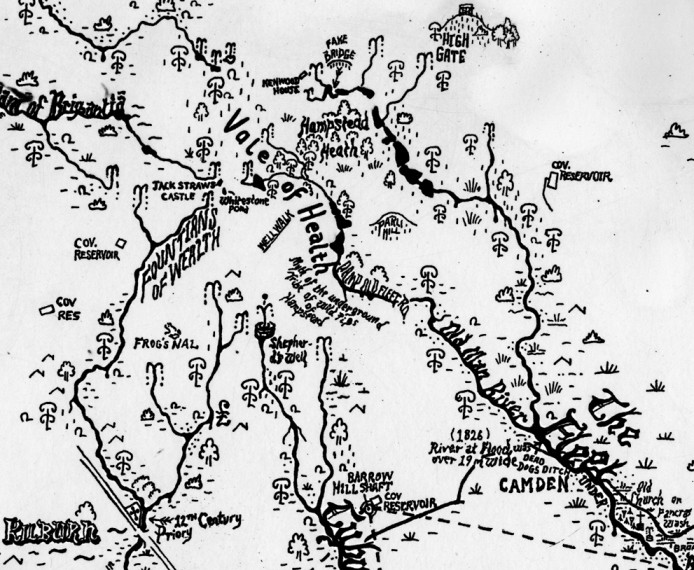
This is a new work by Stephen Walter, in his characteristic hand-annotated, monochromatic style. It features London’s watery features, in particular the many waterways. The iconic River Thames (which should always appear on any good London map) is the natural centrepiece, but London has numerous more minor rivers, streams, channels and culverts which form the base of this work. The choice of water is a particularly good one – London’s waterways are scattered throughout the capital, rather than intensifying in the centre as tube lines and houses (the focus of some of the artist’s previous works) do. This results in reasonably even areas of white space, complementing the intense detail for the rivers (and surrounding lands) themselves that are a hallmark of Stephen’s style. The completed work therefore doesn’t overwhelm with information or feel unevenly cramped, so it is rather pleasing to the eye as a complete piece. The artist has used several different font styles to denote different kinds of features, and included various historical annotations, such as marks of major floods. The work can be viewed on the TAG Fine Arts website or at their studio in Islington, where it can also be purchased, as part of an edition of 50. If you are a long-time Mapping London reader and are thinking that this style looks familiar, you’d be right, we’ve featured works by Stephen Walter a couple of times before. We’ve also previous featured maps of underground rivers and even tube-style maps of the waterways. As an aside, prolific London blogger Diamond Geezer‘s 2015 project is walking the Unlost Rivers of London, many of whom are included on the map here. Thank you to TAG Fine Arts for the complementary ticket to the London Art Fair, where The Rivers of London...

»»
City of Westminster – A Hand-Drawn Map Print
  • Art
Mar25

City of Westminster – A Hand-Drawn Map Print...

posted by Ollie

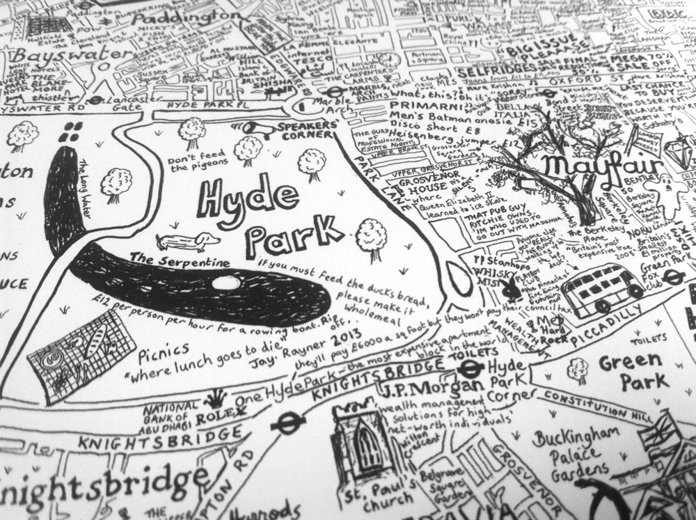
City of Westminster is the first in a series of hand-made maps of London Boroughs that Lovely Jojo has drawn. The black-and-white, text-heavy style, full of commentary as well as placenames, reminded me at first of Stephen Walter’s maps, however on looking closer, the style is quite different, with an alternative interpretation of each object and place. The styling is not quite as intense, giving the map space to “breathe” while still featuring a huge number of vignettes across the borough. Lovely Jojo has produced a limited number of prints of the City of Westminster map, on fine art paper, which can be purchased from her online shop. The artist has plans to map the other boroughs but she acknowledges it will take quite some time. Her Twitter feeds hints at a Hackney map on the way. I look forward to my own borough appearing! Thanks to Lovely Jojo for sending a review copy, which is photographed...

»»
The Mapping London Christmas List 2013
  • Events
Dec12

The Mapping London Christmas List 2013...

posted by Ollie

Here’s some of our favourite maps we’ve reviewed over last 12 months, and where you can buy them: Running with Crayons is a fantastic name for an artist’s portfolio, and we loved the beautiful and colourful hand-drawn maps of London we looked at in April. You can buy the maps of East London and South-East London, amongst others, at Tilly’s BigCartel Store.  Stephen Walter is selling a digital copy of his London hand-drawn maps, on an iPad app, Walterian London. We liked the Hub Map of London and London Subterranea particularly. See more about the app on the iTunes Store.  In July we reviewed a new reproduction box set of the A-Z 1938 London Street Atlas, which comes in an attractive case and is available through Amazon.  London Dissected is the fourth in the Curiocity series of quirky, and genuinely pocket sized, maps. Each one has a different theme, this one reimagines London as a human body. The map is packed with gory locations and related trivia. We reviewed it in August and you can get it, and the others in the series so far, at the Curiocity website.  Rocque’s Map of Georgian London is a modern reproduction of a 1746 map showing London in great detail. The reproduction comes in an attractively boxed set of four maps. We featured it in August and it’s on sale at Amazon.  David Fathers has created a poster of the Thames as it flows through London. See our review and buy it direct from the illustrator.  Last month we reviewed Craft Beer and Coffee Maps and you can get them from the Blue Crow Media shop, along with a Cocktail Bar map.  The Adventure Walks Map – we reviewed this just yesterday. Buy it here on Amazon. ...

»»
Anthropocene Exhibition
  • Art
Jul08

Anthropocene Exhibition...

posted by Ollie

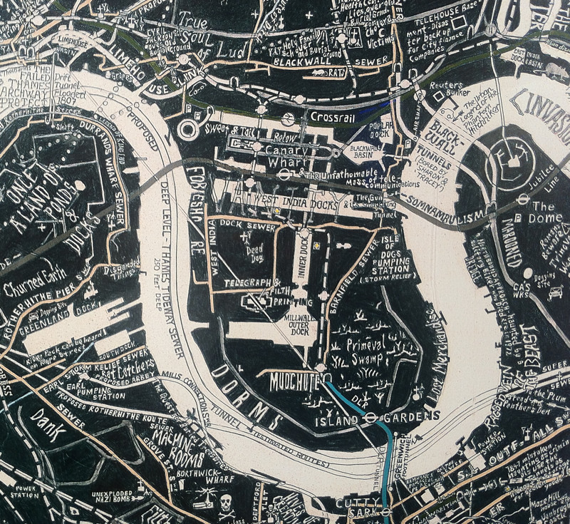
Stephen Walter, most famous for his “Hub” map of London, a fantastically detailed hand drawn map of London with a distinctive repeating style and thousands of anecdotes drawn into it, has a solo exhibition at Londonewcastle in Shoreditch, for the next month. As well as his London “patchwork quilt” maps, the exhibition includes some other artwork such as a sea of bicycles, and more abstract “icon” artworks, of which an extract of one is below. The extract above is from London Subterranea, a commission for the Transport Museum, which focuses on networks and features below ground. The tube lines are shown inverted, so the DLR (in the extract here) appears to emerge from the earth at the point it actually goes underground. Another highlight, which takes up an entire wall at the exhibition, is extracts of “Hub” for each of London’s 32 boroughs and the City, each individually framed and then arranged on the wall pseudogeographically. The gallery space itself has a minimalist industrial feel to it, which complements the largely black-and-white pencil-drawn work that is Stephen’s signature style. The exhibition is free and definitely worth taking the time to visit. It closes on 27 July. Thanks to TAG Fine Arts for inviting Mapping London to the exhibition...

»»
UCL Hand Drawn Map of London
  • Art
  • People
Dec05

UCL Hand Drawn Map of London...

posted by James

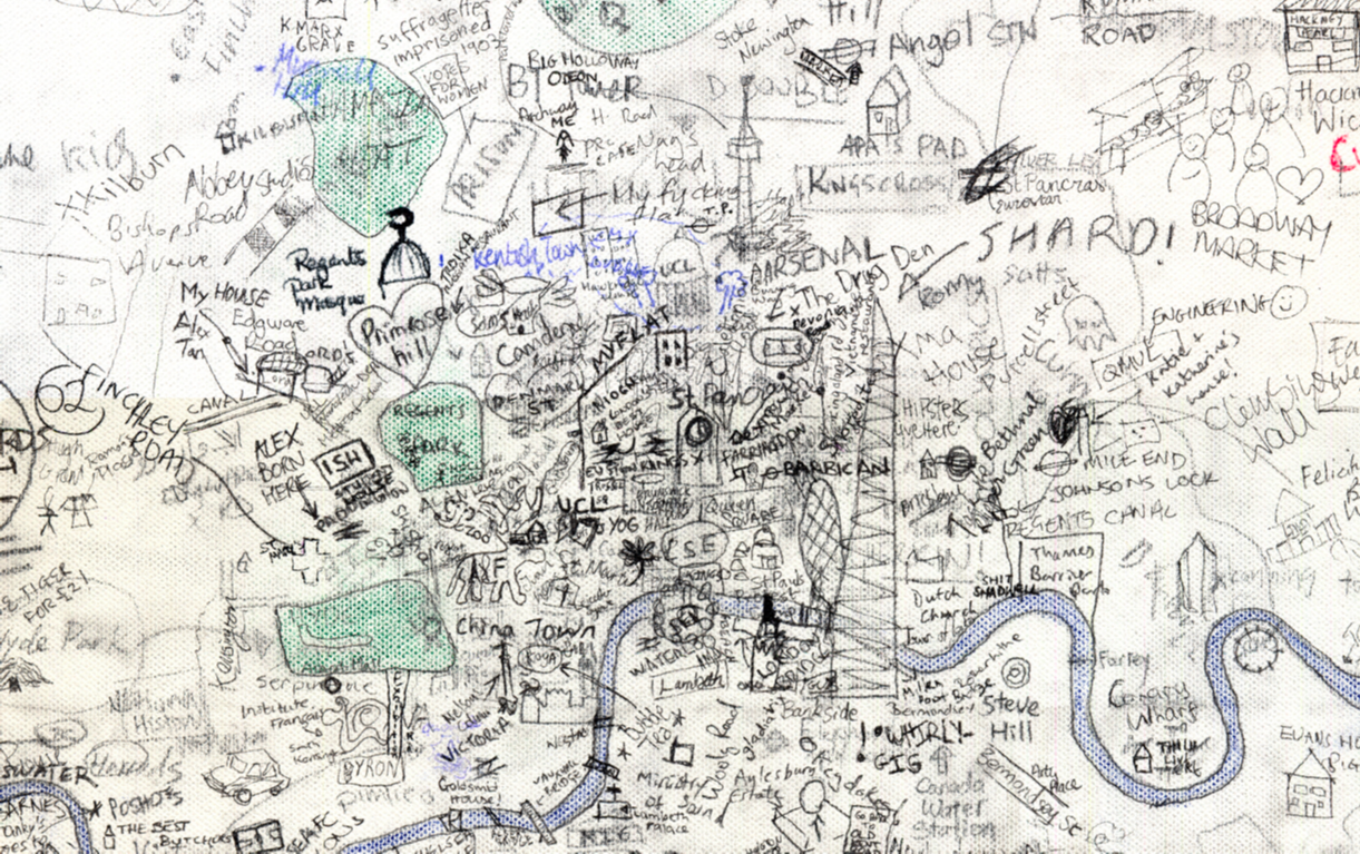
Step aside Stephen Walter, over 270 UCL students (and staff) have created their own interactive hand drawn map of London. Organised by two students Alistair Leak and Ian Morton from the Centre for Advanced Spatial Analysis, the map has brought out some great insights into what people think of their city. Sometimes inaccurate, frequently crude but always personal, the map could serve as an abstract and slightly whacky guide to modern day London. Highlights include Battersea Dogs Home: …the Queen Victoria Pub: …and the Crystal Palace Dinosaurs: Alistair and Ian were keen that all contributors get a mention by making sure they signed around the edges. You can see some of them in action...

»»
Mapping London Life
  • Data
  • Events
Nov18

Mapping London Life

posted by James

Mapping London Life is the title of the talk I gave at a great event organised by the Londonist and hosted by TAG Fine Arts. Surrounded by the wonderful maps in “The Art of Mapping” exhibition and speaking alongside John Kennedy and Stephen Walter the audience and I were in good company for 90 minutes of London map talk. For those who missed it I have included some of the slides, maps and videos that I talked about in my presentation. I have only been able to include those we have formally released so I am afraid one or two are missing. First up was a map of London Bollards. I used this to demonstrate that even though John Kennedy’s Bollards of London blog may seem a bit fanatical to you and I, he is not alone in his interests. All the bollards on the map below have been voluntarily mapped as part of the OpenStreetMap project. The map was produced using a great new tool called GEMMA (soon to be released) developed at CASA. Next up I showed a couple of maps that demonstrate my personal interest in some of the social issues affecting Londoners. The first illustrates the great educational divide in the city. Each Borough has been scaled by the number of children who took GCSEs in 2010 and then coloured by their grades. The map below shows a similar divide in the cuts to London Boroughs announced late last year. The Boroughs this time have been scaled by the number of children living in poverty. Next up were a couple of snapshots, featured in the Times Atlas of London, of the interactive map of London surnames I produced earlier this year. Click on the image to go to the map itself. After this...

»»

Welcome

We highlight the best maps of London. People, places, data, things. Twitter: @MapLondon

The Editors

OllieOllie O'Brien
Editor
Blog / Twitter

JamesJames Cheshire
Editor-at-large
Blog / Twitter

We accept maps for review. Our address is: Ollie O'Brien, Dept of Geography, UCL, Gower Street, London WC1E 6BT. Or email us: ollie (at) mappinglondon.co.uk


Popular Now

  • Victorian London in Incredible DetailVictorian London in Incredible Detail
  • Tour Bus Maps!Tour Bus Maps!
  • Tree Canopy CoverTree Canopy Cover
  • Layers of LondonLayers of London
  • 3D Map of Nitrogen Dioxide Pollution3D Map of Nitrogen Dioxide Pollution

Editorial Policy

We are happy to accept maps for review, and we also provide affiliate links where these are available. We also sometimes include Amazon UK referral links to provide direct links to buy books/maps that we feature.

Our reviews are strictly editorial and of the reviewer’s opinion. We do not accept payments for reviews or sponsor article placement.

We welcome custom affiliate programs if they offer London maps, contact us at ollie (at) mappinglondon.co.uk.

On Amazon

The Book

Order LONDON: The Information Capital. Co-authored by co-editor James Cheshire, it has many data maps of the city.

Designed by Elegant Themes | Powered by Wordpress

This website uses cookies to improve your experience. We'll assume you're ok with this, but you can opt-out if you wish.Accept Read More