
Curiocity is a weighty tome, written by Henry Eliot and Matt Lloyd-Rose and published recently by Particular Books. The book follows on from a short, alphabetically organised series of pocket maps, some of which that we featured (C) a few years ago (D). This is a book which certainly delivers on its back-cover promise to “see London differently”. The work is eclectic, stretching to 452 pages long and bound attractively in a rough fabric cover. The title and front-page font being in the font “Johnston” famously seen on all signs on the London Underground. The title itself contains two footnotes, and the indices include sections by year, people, place, day of year, day of month and day of week, time of day, fonts and even a puzzle. With this level of detail, before even considering the main body of text, you know you are in for a treat.
The book is loosely structured in chapters from A to Z, or Atlas to Zones, but when that goes via Hagiolatry, Mint and Wyrd, then that gives some indication of the quirky nature of the topics written about, and that this is not a “conventional” London guide – more a compendium of miscellany than a discourse on history or geography, although it includes plenty of both of those too. There are footnotes galore – many pages have several, allowing the more specialist-interest reader to get the extra detail they desire.
The book includes a numerous artistic maps, commissioned specially, and produced by a number of artists, and it is just four of our personal favourites, from within the book, that we feature and review here:
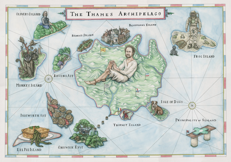
1. The Thames Archipelago (top)
Mapping the more significant islands that are on the River Thames as it flows through London and beyond. This is an attractive, whimsical map – it won’t navigate you to the islands itself, nor show where on the Thames they lie, rather it gives you a flavour of the land on each island itself – how it looks now, or how it did when it existed… There are (or, were) more islands on the Thames than you might think. We particularly like the watercolour, organic feel of the map, and the old shipping map style with the rhumb lines.
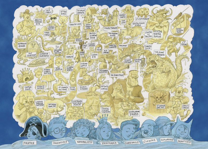
2. Childhood Dreams (above)
Many London locations have a childhood link, be it a setting for a famous book or a modern-day child-friendly tourist attraction. This map frames such locations and curiosities in an approximately geographically correct yet undeniably flamboyant map. The pared down colour palette of yellow and blue keeps the graphic “dream-like”.
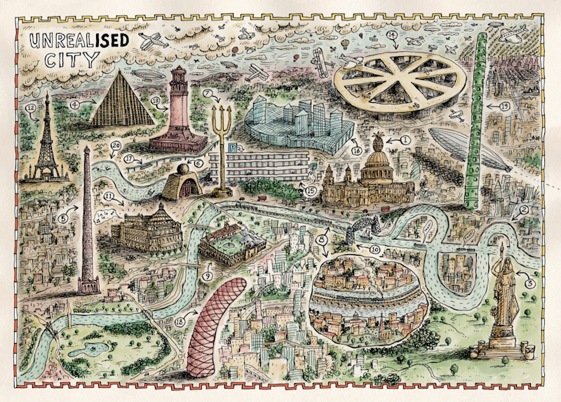
3. Unrealised City (above)
Over the years many people have had ideas on structures to improve some aspect of the London – and many of these ideas never made it of the drawing board. From a railway running down the river, to an octagonal airport on the roof of King’s Cross and London’s own Eiffel Tower. This map puts 20 of these ideas on a single page, showing a view of London that never happened – but might have. We like the energy of this map, crammed full of quirky looking things, but still relatable as a map of London with the Thames flowing through as normal.
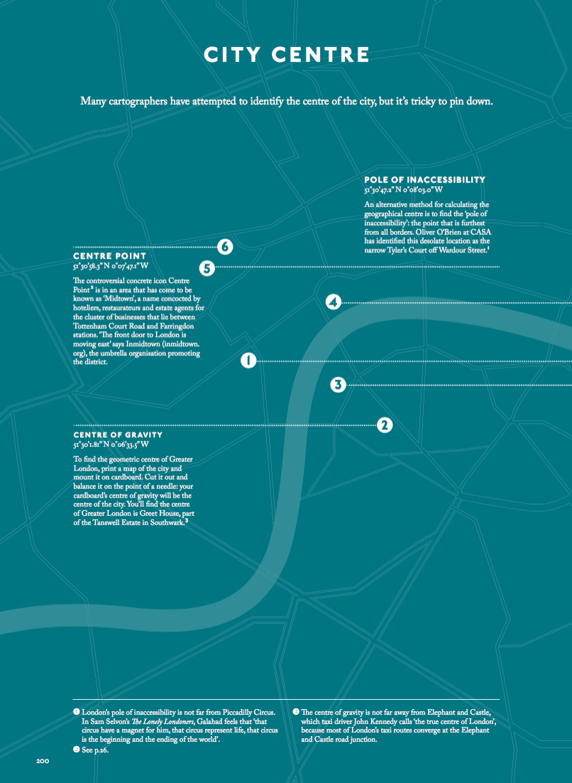
4. City Centre (bottom)
It’s surprisingly hard to define the centre of London – this pared down yet attractive data-driven map, with useful annotations, attempts to do so in a multitude of ways (one of which, I only noticed after writing this review and choosing this graphic, cites yours truly). This style of mapping appears throughout the book, with different shades depending on the chapter.
The book is available now from Amazon (listed at £30 but currently at the good price of £20) and in all good bookshops with a “London” section.
Thank you to James Cheshire for loaning the book for review, and Particular Books for sending the digital imagery. Map 1 by Nicole Mollett, map 2 by Chris Riddell, map 3 by Steven Appleby, map 4 by the authors.
New post on CASA blog: Curiocity https://t.co/LQ3OWNgL6Q
#London #LDN RT: Curiocity: Curiocity is a weighty tome, written by Henry Eliot and Matt Lloyd… https://t.co/xk1dFjadhM via @MapLondon
UC London: Curiocity https://t.co/kRqkVgPcIT
Curiocity https://t.co/a1znU0CJG2 | #GIS #mapping
“Curiocity: In Pursuit of London” – We review this quirky new book of London miscellany & pick our favourite maps:… https://t.co/of8yVlKfOJ
RT @MapLondon: “Curiocity: In Pursuit of London” – We review this quirky new book of London miscellany & pick our favourite maps: https://t…
RT @MapLondon: “Curiocity: In Pursuit of London” – We review this quirky new book of London miscellany & pick our favourite maps: https://t…
RT @MapLondon: “Curiocity: In Pursuit of London” – We review this quirky new book of London miscellany & pick our favourite maps: https://t…
RT @MapLondon: “Curiocity: In Pursuit of London” – We review this quirky new book of London miscellany & pick our favourite maps: https://t…