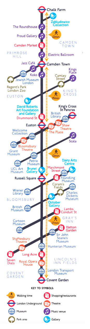

This “line” map of Camden’s cultural locations – museums, galleries and music venues – has been produced by Camden Council and appears alongside a “Legible London” map of the borough and surrounding areas. I like the concept of simplifying a normal 2D right down to a straight line (although the actual route itself does involve a number of turns that the map doesn’t hint at) to simplify and filter London’s dense network of attractions and places of interest into a straightforward narrative. Segment walking time indicators and tube stations help to break the line up into easy sections. The idea is simple and compelling, it is perhaps all you need to spend a day in London as a tourist (with the regular map to look at as a useful backup or for more detail).
Each of the cultural locations are represented as a circle, the colour of the circle and inner symbol showing the location type. The use of straight lines and circles is reminiscent of a tube map, with the “stations” along the line (and branches off it) being the cultural attractions.
The idea could easily be extended to cover over popular London tourist/cultural areas, such as along the South Bank/Bankside or through Strand/Fleet Street/the City.
I spotted the map in the Wellcome Collection, one of the museums included along the line. It’s available from the front desk, as a sheet from a tear-off pad. The map is produced by the London Borough of Camden Creative Services/Arts and Tourism Team.