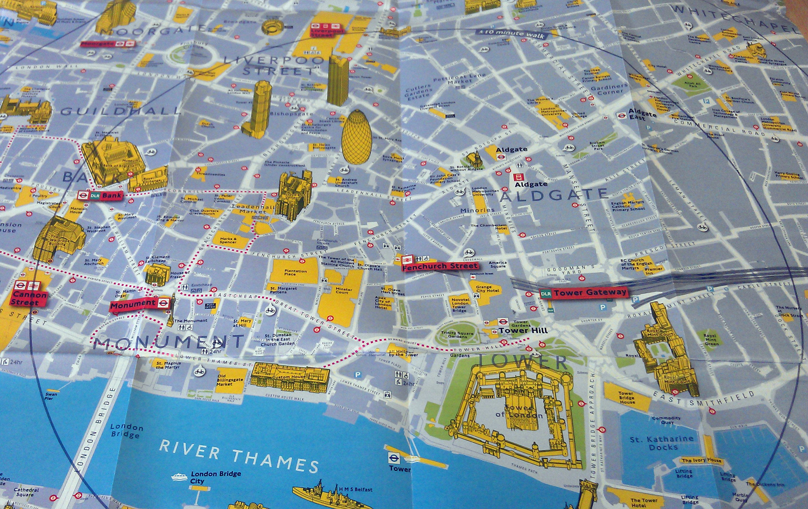

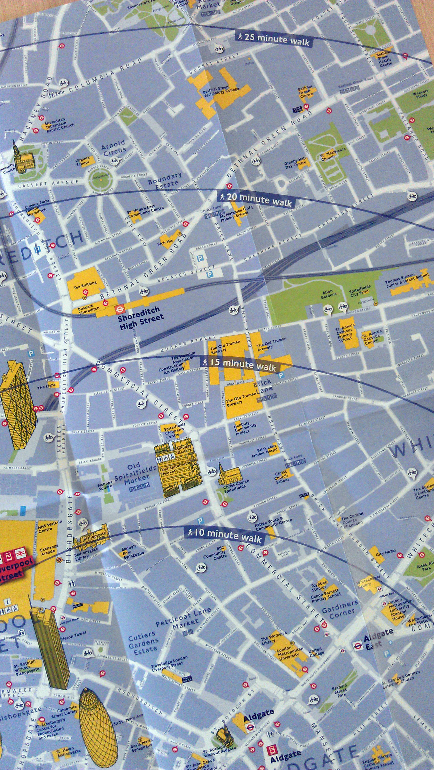
TfL have produced a nice range of maps to promote walking instead of public transport (especially during the Olympics). The maps use different cartography to the other walking maps TfL have produced, and feature a nice range of pseudo-3D buildings and key landmarks. There are also 4 concentric circles that give an approximate walking time up to 25 minutes away. These have been centred over the “hotspot station” the map was produced for- in this case Fenchurch Street.
The maps were being handed out to hardened city commuters who I expect do most of their onward journey by foot anyway. Hopefully TfL will continue to distribute these maps right up to and throughout the games. I can’t seem to find an online version of these so keep an eye out for them at your local “hotspot” station (of which there are many).
Those look like they use the same cartography that was developed as part of the Legible London scheme, and used on the maps at Boris Bike terminals (with concentric rings denoting cycle distances), and on the standalone pillars that are dotted around central London showing walking maps. It’s very striking and easy to follow.
These maps are excellent – very easy to read and follow. For those of us with deteriorating sight they beat the A-Z hands down. So much so that I’d really like a set and be prepared to pay for them!
Wheer can i order some of these maps?
Typical LUL … they have a really good idea then completly wreck the implementation.
(Like P.A. on the tube – good for emergencies – the rest of the time SHUT UP!)
I got one at Liverpool Street & Kings’ Cross, at Victoria the so-called “Information office” didn’t know they existed (!), Waterloo had run out (!) and I only got one at London Bridge, because a barrier-guard had a spare one (!)
Why can’t thes arrogant idiots get it right occasionally?
Particularly as these maps should continue to be available after the Kraft durch Freude “olympics” are over….
I’m an idiot AND I’m disabled with severe mobility issues how can these maps help me eh?. And I have issues around abandonment too!
I went to several of the stations and got the maps 🙂
Victoria (the biggest map)
London Bridge
Charing Cross
Paddington
Euston
Liverpool Street
Elephant and castle
These maps can be put together to make a large section of central London, (with a lot of overlapping)
Good effort Ian – & bonus points if you walked between each of the stations!
I did actually walk them 🙂
I have more now also:
Greenwich & Woolwich
Stradford & East London
These 2 are huge & slightly different style to the rest of the maps
Cannon Street
Kensington
Kings cross
Ian, I’m hoping to do the same! I have yet to collect all the required maps.
LOVE this site by the way
So far I have found TfL maps of the Why not walk it? type with the cover entitled as shown below for the railway station ……….
Paddington
Marylebone
Euston
King’s Cross / St Pancras International
Liverpool Street
Fenchurch Street
Cannon Street
London Bridge
Waterloo
Charing Cross
Victoria
plus
2 more “district” walking maps not specifically based on one railway station
Elephant & Castle
Greenwich / Lewisham
Sorry readers – in my last post the last entry should read …………
Greenwich / Woolwich and not Greenwich / Lewisham
it covers the Games venues at the O2 and Woolwich Barracks
I have;
London Bridge
Charing Cross
Paddington
Euston
Liverpool Street
Stratford
Kings Cross
Fenchurch Street
Waterloo
Cannon Street
Have a few more to get though by the looks of it. Has anyone seen them at any other stations??
Thanks x.x
Following Ian’s prompt above I picked up copies of the Stratford & East London walking map and the “Continuing your journey in the Olympia area” map yesterday so now we can summarise what is available as:
Why not walk it? type with the cover entitled as shown below for the railway station ……………….……….
Paddington
Marylebone
Euston
King’s Cross / St Pancras International
Liverpool Street
Fenchurch Street
Cannon Street
London Bridge
Waterloo
Charing Cross
Victoria
plus
4 more “district” walking maps not specifically based on one railway station…………..
Elephant & Castle
Greenwich & Woolwich
Olympia
Stratford & East London
Perhaps you’ll post any further finds here readers. Can there be more????
Please contact Walking@tfl.gov.uk if you would like to order a copy of any of these maps. alternatively you can find them at mainline railway stations!
I couldn’t agree more with this idea 🙂 I always prefer walking round London compared to getting the train, tube etc. You see far more firstly & it gives you the excuse of being able to enjoy cake as you can burn it off! Kensington is my fave place to stroll around, lots to see & plenty of cafe’s you would otherwise miss if underground
Hi all,
could sound silly but I’m trying to collect all maps and stick together in a big wall picture.
I called TFL asking for a digital version but unfortunately it is not available as well as the big poster.
If anyone has useful information please keep update through comments.
Cheers
@nedboulting @dublincycling https://t.co/b3m74siInN these were great during the Olympics in 2012 – walking maps cen… https://t.co/853RHRTdoN
RT @thebellow: @nedboulting @dublincycling https://t.co/b3m74siInN these were great during the Olympics in 2012 – walking maps centred on v…
RT @thebellow: @nedboulting @dublincycling https://t.co/b3m74siInN these were great during the Olympics in 2012 – walking maps centred on v…