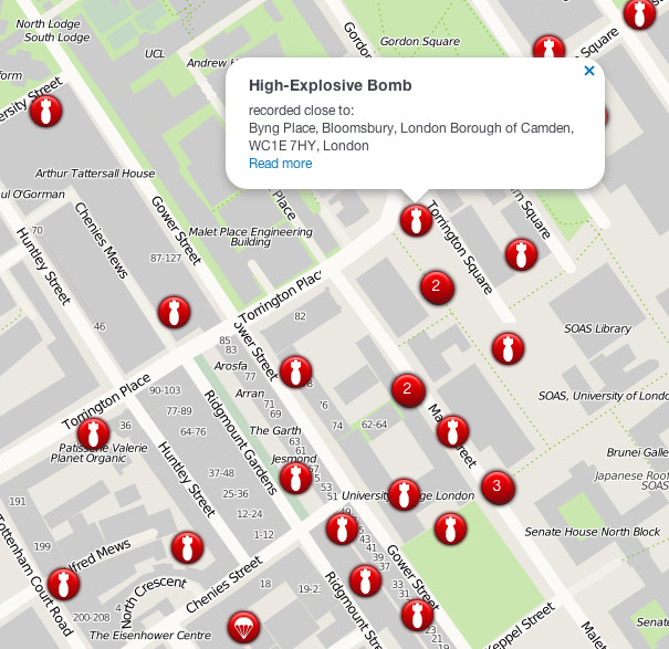

The London Blitz, from 1940-1941, was a traumatic event that changed London’s landscape for ever. Until now, maps of the impact sights from the bombs falling on the city, have remained in paper form and have only been available to view when travelling to public archives, or through specialist planning consultancies. We have featured one such map on this website a few months ago. Now, researchers from the University of Portsmouth and UCL, funded by JISC, have released a new website, Bomb Sight, which has digitised the impact locations and plotted them on modern and historical maps. Initially you’ll see clusters of red dots across the city – on zooming in the dots turn clickable and you’ll be able to find out additional information about each bomb and the impact it had on the area. There are three filters – you can view the first night, first week or the whole period. There is also an application available shortly for Android-based smartphones, developed by Geobits, which shows an augmented reality view – you can walk through the streets holding your phone, and it overlays the locations of nearby impact sites on your view of your current street, as it was 70 years ago.
The effort to accurately digitise maps like these is far from trivial and it is an impressive example of discovering a public interest in information like this by making it readily viewable. The site received very heavy attention from the mainstream media earlier this week, so we have delayed featuring this map until now, the site is now accessible and responsive after having suffered somewhat from a different kind of impact – enthusiasm – earlier.
Congratulations to the Bomb Sight team and I look forward to further spatial data analyses of this fascinating and unique historical dataset, particularly as, in time, the data will be available for research by other academics and non-profits.
Excellent site and one I shall be using to illustrate History classes with.