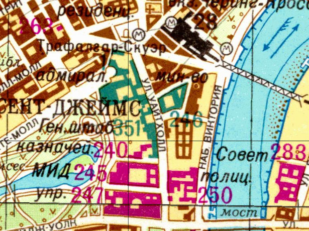

As a followup to yesterday’s article on the Soviet Cold War maps of London, above is an extract sent from the Landmark Information Group, which has acquired a large number of the maps. The extract is of a particularly interesting area in the very centre of London – Whitehall – a place which would be high on the list of areas that Soviet military planners would be interested in. The main ministeries are shown in pink, with numbers that presumably correspond to a key. Ceremonial buildings appear to be shown in green, such as Horseguards Parade, while Charing Cross Station, and the three tube stations near it, are also clearly marked. The River Thames has arrows showing it as a two-way navigable river – the downstream arrow shows direction of river flow, the upstream arrow with flights indicates tidal flow (thanks John for the clarification!)
For contrast, below is the current OpenStreetMap map of the same area, supplied by CloudMade. I’ve used the CloudMade Style Editor to mimic some of the colours.
The above image is Copyright 2011 Landmark Information Group. All rights reserved. The below image is from Cloudmade and is CC-By-SA OpenStreetMap and contributors.

Good guess, but not quite right about the two arrows! Downstream arrow shows direction of river flow, upstream arrow with flights indicates tidal flow. Navigability is indicated by the river name being in capital letters (not visible in this extract).
John
The images have gone…
Thanks Laurence, this was one I forgot to fix when we moved across to a new server. Should be OK now though.