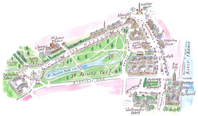
It’s lovely to see a brand new hand-drawn map of London in this age of computer-generated graphics. This one has been produced by Michael Hill of Maps Illustrated for this week’s TV Guide and shows the Diamond Jubilee procession route up Whitehall and down The Mall.
The effort stands in marked contrast to the maps produced for the festivities over the weekend that have relied on Google. The processional route map on the official website demonstrated uses Google Earth (plus some suitably regal music).
Whilst, the map used on the official website for the Thames Pageant (another part of the Diamond Jubilee celebrations) uses an underwhelming standard Google Map – it’s not even styled to match the red, white and blue theme of the the event or indeed the rest fo the website. The cartography of the standard Google Map is great for general travel around London, but for a special occasion like this, the map could have been so much more.
Thanks to Michael Hill for letting us know on Twitter about the map. His blog article includes a higher-resolution version.

“The cartography of the standard Google Map is great for general travel around London”.. I think that’s rather generous. Sometimes google maps is not even suitable for the most basic navigation. #switch2osm
That example is a little unfair, although I understand your sentiment. Google was wrong for a period of time, but fixed it in due course. OSM also can be wrong for a period of time, if some does accidental or malicious vandalism.
Hello,
Just a quick email as I noticed your Diamond Jubilee Map; the Thames Jubilee Pageant Infographic and map from LondonTown.com can be embedded (for free) and thought you might want to include it in your article: http://LondonTown.com/PageantMap
Oooh, I really like that one!
This is possibly a perfect diagram. Firstly; engaging and attractive. Then; functional and useful to all wanting to experience the pageant; then multi-layered – the more you study it the more information it reveals. I had not realised initially how it explains the structure of the pageant so well through the labels on the river bank but then look closer and each individual boat is accurately illustrated. I took a look at the LondonTown.com site and again the provision of written information suporting the map was highly organised, engaging and functional.