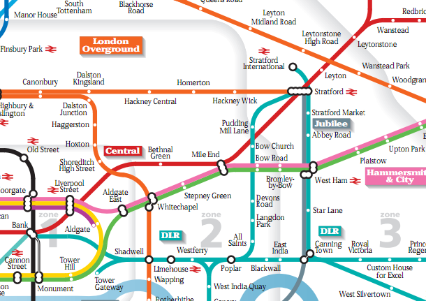
The “Beck” London Underground map is probably the most iconic and recognisable map of London in the world. As such, it is a favourite for reworking. Numerous unofficial versions exist – with the names replaced, or the lines drawn geographically rather than topologically, or different colour schemes. Some examples can be seen here.
Recently, two alternative versions have appeared. Both these versions stick to the Beck constraint of only allowing lines at certain angles, but allow the 22.5-degree angle as well as the classic 45-degree and 90-degree angles. The first is the Underground Overground Map (PDF) by Andrew Smithers, part of his Project Mapping website. The second is the London Tubemap by Mark Noad.
Focusing on Andrew’s version, I love the larger circles – in particular, the Thames around Canary Wharf, and the tube loop around Heathrow Airport, both make near-perfect circles, rather than the rounded rectangles of the official map. Very complicated stations, such as King’s Cross and Stratford, are shown as a single long line of “connector circles” rather than the Meccano-style ones that are now appearing. These lines are cartographically much prettier although they do increase the footprint of the station still further. I also like the detail of Edgware Road, where the two circle-line paths are clearly separated by using different angles. The Thames also is properly wiggly and fades away as it narrows to the west.
Mark’s version is similar, although the circle radii are smaller and there are more kinks in the lines, which is a necessary compromise as the map is more geographically accurate than both the official map and Andrew’s. I like the “interchange for national rail” symbol being enclosed properly within the connector circle, rather than proliferating as seperate icons on the official map.
Both maps are up-to-date, with the soon-to-be-opened DLR spur to Stratford International included on the maps.
The maps remain the copyright of their respective authors and are not associated in anyway with Transport for London or the official London Underground map. TfL are (rightly) very protective of the copyright of their Beck-designed map.


You’ve missed out on all of these!
http://diamondgeezer.blogspot.com/2010/03/underground-maps-unravelled.html
http://www.ianvisits.co.uk/blog/2010/10/08/for-2-weeks-only-alternative-tube-maps-on-display/
http://www.youtube.com/watch?v=Fgk11BY9v3w
http://london-underground.blogspot.com/2008/02/curvy-tube-map-re-visited.html
http://privatewww.essex.ac.uk/~mjr/underground/Breaking_the_rules.pdf
http://vimeo.com/channels/ignitelondon4#20687329
Thanks Max – I particularly like your curvy map. There will be another post on alternative underground maps sometime soon – there are too many not to share, although need to do the odd non-tube one once in a while!
Madrid, Paris, New York? All done and shown at my larger exhibitions, but not always photographed by reviewers!
Madrid Metro map twice as fast for planning as the official version:
http://privatewww.essex.ac.uk/~mjr/underground/media/InMadrid.pdf
Paris Metro Map 40% faster for planning than the official version:
http://privatewww.essex.ac.uk/~mjr/underground/media/Kunst-SZ_merzig_231110.pdf
http://privatewww.essex.ac.uk/~mjr/underground/media/Saarbucker_Zeitung_en.pdf
I like the second map. Living in Tooting it reminds me that I’m not too far away from everything really.